Εμφάνιση αναρτήσεων με ετικέτα Natural Environment. Εμφάνιση όλων των αναρτήσεων

Σάββατο 6 Ιουλίου 2024

Metropolitan Jeronymos of Uganda on Water and Environment for Climate-Resilient Development


Clear Air, Clear Water. Credit: Michael Foley/ CC BY-NC-ND 2.0 / Flickr

Uganda Orthodox Church

His Eminence Metropolitan Jeronymos Muzeeyi of Kampala delivered his remarks on Water and Environment for Climate Resilient Development during the commemoration Week held in March 2023 amidst dignitaries from different divides of the country.

Reflecting on World Environment Day which was celebrated yesterday 5th June, we share his presentation which focuses on the teachings of the Ekklesia on ecological theology and humanity.

Presentation on water and environment for Climate-Resilient Development

I sincerely believe that an integrated and interdisciplinary approach to water and environmental issues can help our country Uganda, not only to be “the pearl of Africa”, but also to be truly the “Garden of Eden” of the holy scriptures. My remarks here below are a reflection of theological thoughts on the matter. Man is at the center since he was created in the image and likeness of the creator, God. And he was entrusted with the vocation “to cultivate it and to keep it” (Gen: 2:15).

  1. God’s creation was very good.

When faced with the ecological crisis of our times, obviously, there are many questions that raised. One temptation can be, among the questions raised to put the blame on God, the creator. But the scriptures’ narrations have no room for such a blame. For they say: on completion of His six-day creation “God saw everything He had made, and behold, it was very good” (Gen. 1:31).

Very important was God’s care for water in the garden of Eden: “A stream flowed in Eden, it divided into four rivers” (Gen. 2:10). In this creation, man who was created in God’s image, had a vocation. “to … cultivate it and keep it” (Gen. 2:15).

There must be a reason why. The very reason could be summarized by saying: This world was given to man as a gift, – “a gift from God the Creator, a healing gift, a gift of wonder and beauty. Therefore, man’s proper response upon receiving such a gift, is to accept and embrace it with gratitude and thanksgiving”. In otherwards using it well for the glory of God.

Metropolitan Jeronymos blessing water water during the Theophany of our Lord
  • Man’s sin is the root cause of ecological crisis.

Man sinned. In his sin, everything changed. One could ask, what is sin? Sin is man’s rebellion against God the creator. His refusal to live by God’s will. It is the perversion of God’s purpose and order put in nature: (A good example in this case is homosexuality!). It is man’s deliberate refusal to have communion of love with God, fellow man and creation. As a result, man actually failed in his vocation. Instead, man was “passed under the domination of sin and of the evil”. Certainly, as a result of man’s sin, the human mind became so darkened, and the human will was impaired”. He could live by “exploitative control of resources”.

All times, he could be a being of “selfness and greed”. In this case, there was a need for an ontological transformation. This is what we call man’s repentance. You and I must repent to save human nature, to save the creation. In our fallen nature, St. Paul, could reveal the truth: “the whole creation groans and labors with birth pays” (Rom 8:22).

  • Christ’s mission of re-creation.

Le me make it very clear from the outset that, true Christians are and must be environments. This is because, the incarnation of the Word of God was to liberate man from his rebellion and in the process, the whole creation. Man in Christ is a new creature, something we referred to above as ontological transformation. To accept Christ, he must repent. A new creature is a son of God. He lives by the will of God St. Paul had noted it that “Creation eagerly waits for the revealing of the sons of God” (Rom 8:19). Since “It will be delivered from the bondage of corruption into glorious liberty of the children of God. (Rom. 8:21). “The loving re-creation of the world by the divine word at the incarnation of God’s Son is very crucial in our understanding of our mission as followers of Jesus Christ. Indeed, Christians have to be models and have to play a decisive role in solving the environment crisis.

  • Man’s communion of love is the Key.

Earlier, we made it clear that man’s communion of love with God, his fellow man and creation was weakened as result of man’s rebellion. In Christ, man is reconciled to God. He is as well asked to live in communion of love, with fellow man and creation. Man’s vocation to receive creation as a gift from God is restored. His preparedness to us it well for the glory of God is manifested. Christ’s Church, which is an extension of the redeeming of mission, ever accept and embrace God’s gift with gratitude and thanksgiving in all its service. 

As a matter of fact, our generation has to understand that we are called upon as Christians to live fully in the communion of love for the salvation of creation. Important to note, this planet is “our home … it is also the home of everyone, as it is the home of every animal creature, as well as every form of life created by God”. Our generation should consider the same for the generation to come. The air we breathe, the water we drink and is the source of life, if it is defiled, the element and essence of our existence are threatened. This is true for us and for the generations to come.

  • Efforts to protect god’s creation.
Metropolitan Jeronymos planting a tree during the feast day of the presentation of Theotokos in Magoma

God’s people are called up to protect God’s creation. Who are God’s People? These are redeemed by Christ. Living by the will of God. These are sons of God by God. These are the people prepared to fight the evils of individualism and consumerism propelling the spirit of egoism. At the center of egoism is self-interest. Very often, man puffed up by egoism in our world of technological advancement leaves no room for God. It only brings about the spirit of secularism. Here man moves away from God’s creation. He creates his own world without God. In the Garden of Eden, we saw the rivers flowing. 

In man’s megacities, we see filth liquids flowing. Man must change. Man must change. The prophetic voice of the church is about the change. And this change means addressing poverty, inequality, discrimination, marginalization, domination, exploitation, etc. in all their forms. We must become “children of God by grace” to become Children of God to be fully committed to the will of God. This means to do away with egoistic tendencies. To be children of God also means to be faithful to God’s purpose and intent for creation. Environment degradation and destruction are torment to suicide.

Σάββατο 3 Ιουνίου 2023

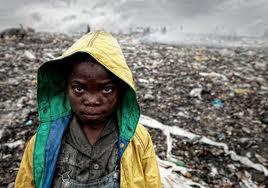
Rubbish in Mozambique

Londinoupolis

Growing up in a European capital where rubbish is put in the dustbin and from there the rubbish dumps, which I do not know and in a way I don't want to know where they are. People in the cities choose to distance themselves from these facts and get quite annoyed when the trash is not collected on time. 


However we forget various other places around the world which receive our rubbish. It is a fact that trash is moved around, massive quantities are thrown in the oceans and the third world. These of course produce many illnesses and infections to the people close to this 'mountains of rubbish'. 


Are the pictures here the answer to the problem in the 21st century? We have been hearing that a futuristic solution would be to send our rubbish into space. Maybe recycling should be taken more seriously. These images are appalling, showing how colonial attitudes from the Western powers towards the South, mainly Africa, continue even in the post-colonial era. 


Παρασκευή 3 Ιουνίου 2022

«Tα πρώτα θύματα της κλιματικής αλλαγής είναι οι φτωχοί και ιδιαίτερα τα άπορα και ορφανά παιδιά της Αφρικής...» Πατριάρχης Αλεξανδρείας Θεόδωρος


Η Κλιματική αλλαγή και η Αγία και Μεγάλη Σύνοδος


Του μητροπολίτη Ζιμπάμπουε Σεραφείμ Κυκκώτη

ΒΗΜΑ ΟΡΘΟΔΟΞΙΑΣ / Στον Ορθόδοξο Αμπελώνα της Αφρικής

Οι εργασίες της Συνδιάσκεψης του για τη Κλιματική Αλλαγή στο Μαράκες του Μαρόκου που ξεκίνησαν στις 7 Νοεμβρίου και θα ολοκληρωθούν στις 18 Νοεμβρίου (COP22), δίνουν νέες ελπίδες για να προστατευθεί η Ανθρωπότητα καi το μέλλον της επιβίωσης του Πλανήτη μας.

Στην Συνδιάσκεψη συμμετέχουν Αντιπροσωπείες 197 Κυβερνήσεων, Διεθνείς Οργανισμοί και ένας μεγάλος αριθμός ΜΚΟς που ασχολούνται με θέματα της Κλιματικής Αλλαγής, ως επίσης και Ακαδημαϊκά Ιδρύματα, Επιχειρήσεις και Βιομηχανίες, το Π.Σ.Ε και εκπρόσωποι Θρησκειών.

Σε διάφορα επίπεδα θα εξετασθούν τα θέματα της εφαρμογής του Πρωτοκόλλου του Κυότο μέχρι το 2020, θέματα εφαρμογής των προηγούμενων αποφάσεων για δράση για τη Κλιματική Αλλαγή, συζήτηση για τον τρόπο της εφαρμογής της νέας Παγκόσμιας Συμφωνίας του Παρισιού το προηγούμενο έτος (COP21), οικονομικά θέματα για στήριξη των διαφόρων προγραμμάτων για τη Κλιματική Αλλαγή, παρουσίαση των εκθέσεων Επιτροπών για θέματα Νέας Τεχνολογίας, Επιστημονικά πορίσματα για να περιορισθεί η συνεχόμενη αύξηση της μόλυνσης της ατμόσφαιρας που οδηγεί στην συνεχή αύξηση της θερμοκρασίας του Πλανήτη μας με καταστροφικές συνέπειες για την επιβίωση μας. 

Ταυτόχρονα οργανώνονται διάφορες συζητήσεις στρογγύλης τραπέζης για να παρουσιασθούν οι νέες προσπάθειες για κοινή δράση για τα προβλήματα της Κλιματικής Αλλαγής, λειτουργούν εκθεσιακοί χώροι για πηγές ενέργειας που δεν προκαλούν μόλυνση (πράσινη οικονομία), ως επίσης και ανακοινώσεις Κυβερνήσεων για νέες δράσεις είτε από Αρχηγούς Κρατών είτε από τους Υπουργούς Περιβάλλοντος.

Σε ειδική δημοσιογραφική διάσκεψη και σε Πάνελ για θέματα της Κλιματικής Αλλαγής παρουσιάστηκε η θέση των Ορθόδοξης Εκκλησίας κατά τις πρόσφατες εργασίες της Αγίας και Μεγάλης Συνόδου στη Κρήτη το περασμένο Ιούνιο, ως επίσης και Μηνύματα του Οικουμενικού μας Πατριάρχη κ.κ. Βαρθολομαίου και του Πάπα και Πατριάρχη Αλεξανδρείας και πάσης Αφρικής κ.κ. Θεοδώρου (η COP22 πραγματοποιείται στην Αφρικανική Ήπειρον).

Στο επίσημο κείμενο τής με θέμα «Η συμβολή της Ορθοδόξου Εκκλησίας εις επικράτησιν της ειρήνης, της δικαιοσύνης, της ελευθερίας, της αδελφοσύνης και της αγάπης μεταξύ των λαών, και άρσιν των φυλετικών και λοιπών διακρίσεων», για το θέμα της Οικολογικής κρίσης τονίζεται ότι «Ο πόθος της συνεχούς αυξήσεως της ευημερίας και η άμετρος κατανάλωσις αναποφεύκτως οδηγούν εις την δυσανάλογον χρήσιν και την εξάντλησιν των φυσικών πόρων. Η δημιουργηθείσα υπό του Θεού κτίσις, η οποία εδόθη εις τον άνθρωπον ᾽εργάζεσθαι και φυλάσσειν᾽ αυτήν (πρβλ. Γεν. 2.15), υφίσταται τας συνεπείας της αμαρτίας του ανθρώπου:

«Τη γαρ ματαιότητι η κτίσις υπετάγη, ουχ εκούσα, αλλά διά τον υποτάξαντα, επ᾿ ελπίδι ότι και αυτή η κτίσις ελευθερωθήσεται από της δουλείας της φθοράς εις την ελευθερίαν της δόξης των τέκνων του Θεού. Οίδαμεν γαρ ότι πάσα η κτίσις συστενάζει και συνωδίνει άχρι του νυν» (Ρωμ. 8.20-22). Η οικολογική κρίσις, η οποία συνδέεται προς τας κλιματολογικάς αλλαγάς και την υπερθέρμανσιν του πλανήτου, καθιστά επιτακτικόν το χρέος της Εκκλησίας όπως συμβάλη, διά των εις την διάθεσιν αυτής πνευματικών μέσων, εις την προστασίαν της δημιουργίας του Θεού εκ των συνεπειών της ανθρωπίνης απληστίας.

Η απληστία διά την ικανοποίησιν των υλικών αναγκών οδηγεί εις την πνευματικήν πτώχευσιν του ανθρώπου και εις την καταστροφήν του περιβάλλοντος. Δεν πρέπει να λησμονήται ότι ο φυσικός πλούτος της γης δεν είναι περιουσία του ανθρώπου, αλλά του Δημιουργού : «Του Κυρίου η γη και το πλήρωμα αυτής, η οικουμένη και πάντες οι κατοικούντες εν αυτή» (Ψαλμ. 23,1). Ούτως, η Ορθόδοξος Εκκλησία τονίζει την προστασίαν της δημιουργίας του Θεού διά της καλλιεργείας της ευθύνης του ανθρώπου έναντι του θεοσδότου περιβάλλοντος και διά της προβολής των αρετών της ολιγαρκείας και της εγκρατείας. Οφείλομεν να ενθυμώμεθα ότι όχι μόνον αι σημεριναί, αλλά και αι μελλοντικαί γενεαί έχουν δικαίωμα επί των φυσικών αγαθών, τα οποία μας εχάρισεν ο Δημιουργός».

Eις το πολυσήμαντο Μήνυμά του ο Οικουμενικός μας Πατριάρχης κ. Βαρθολομαίος, μεταξύ άλλων επισημαίνει, «τη αναγκαιότητα της συνεργασίας και της ενότητας των Κυβερνήσεων για κοινές άμεσες δράσεις για να προστατευθεί η Ανθρωπότητα και ο Πλανήτης μας από τα προβλήματα της Κλιματικής Αλλαγής». Εις το Μήνυμα του τονίζεται επίσης ότι «η εφαρμογή της Παγκόσμιας συμφωνίας του Παρισιού του προηγούμενου έτους από όλους θα αποτελέσει δυναμική έκφραση της κοινής θέληση των Κρατών του Πλανήτη μας για την ενίσχυση της παγκόσμιας Ασφάλειας και της ειρηνικής συνύπαρξης των Λαών και της ευημερίας όλων μας». 

Εις το μήνυμα του ο Πάπας και Πατριάρχης Αλεξανδρείας και πάσης Αφρικής κ.κ. Θεόδωρος , μεταξύ άλλων, υπογραμμίζει ότι «τα πρώτα θύματα των προβλημάτων της κλιματικής αλλαγής είναι οι φτωχοί και ιδιαίτερα τα άπορα και ορφανά παιδιά της Αφρικής και των φτωχών χωρών στην Ασία και στην Λατινική Αμερική, εκεί δηλαδή που οι Χριστιανοί της Ευρώπης εισήγαγαν το θεσμό της αποικιοκρατίας και της δουλείας».


Τετάρτη 18 Αυγούστου 2021

Accaparement des terres : le Gabon, dans le top 10 mondial des pays dépossédés

Tout récemment paru, "L’Atlas des Afriques", réalisé le journal Le Monde Afrique et l’hebdomadaire La Vie, classe le Gabon dans le top 10 des «pays dépossédés peu à peu de leurs terres», avec plus d’un million d’hectares vendus ou loués.

© environnement-afrique

Selon le dernier atlas publié par Le Monde Afrique, le continent noir compte la moitié des surfaces cultivables «disponibles» dans le monde. Mais, de nombreux pays étrangers au continent accaparent ces terres, fragilisant la sécurité alimentaire et environnementale des populations locales.

Détail d’infographie publiée par Le Monde Afrique. © Scan par Gabonreview

L’Atlas note que le Gabon compte parmi les pays cibles des Etats-Unis, de Singapour, de la Chine, de la France, de l’Italie et de l’Inde. Si l’emprise de Singapour ne fait plus débat au Gabon du fait des plantations d’hévéa et de palmier à huile détenues par la singapourienne de négoce et de courtage de denrées, on ne devra pas oublier les autres opérateurs forestiers asiatiques, notamment les Chinois. Ceux-ci ont en effet accru, ces dernières années, leur productivité dans l’exploitation forestière, 74% des superficies attribuées à l’exploitation forestière leur appartiennent d’ailleurs. Olam, pour sa part, a «déboisé depuis 2012 environ 20.000 hectares de forêts dans ses concessions gabonaises», selon les données, datant de 2017, des ONG environnementalistes Mighty Earth et Brainforest. Réajustant ce chiffre, la multinationale déclarait plutôt 25.000 hectares, précisant qu’il s’agissait «de forêts secondaires hautement exploitées et dégradées» et que cette superficie ne représentait que 0,1% des zones forestières du Gabon.

Selon les cartes et infographies de l’Atlas du journal Le Monde Afrique, le Gabon figure parmi, «les 10 premiers pays africains, en millions d’hectares vendus ou loués depuis 2000». Il occupe le 9ème rang dans «le top 10 mondial (des) pays où des transactions ont lieu depuis 2010» avec «plus d’1 million d’hectares vendus ou loués».

Les gouvernements complaisants quant à cet accaparement des terres et les investisseurs étrangers complices présentent le phénomène comme un levier de développement, favorable aux agricultures locales et comme une rente devant permettre le financement d’autres projets. En réalité, cet accaparement foncier ne débouche quasi exclusivement que sur des monocultures intensives tournées vers l’exportation et ne bénéficiant réellement qu’aux multinationales et gouvernants corrompus.

L’Atlas fonde son étude sur la base de données indépendante Land Matrix. Se définissant comme une matrice des transactions foncières, celle-ci est une interface en ligne offrant des données et des outils d’analyse sur les transactions foncières de grande envergure. Selon Le Monde Afrique, Land Matrix a répertorié «près de 1800 acquisitions de terres à grande échelle réalisées dans le monde depuis l’an 2000, l’Afrique est la région la plus ciblée avec 33 % de la surface concernée et 34 % des transactions conclues

Κυριακή 8 Αυγούστου 2021

Feast Of The Holy Transfiguration And Blessing Of The Fruits According To Byzantine Rite Tradition

Blessing of the Fruits at the Chirundu Orthodox Church in Zambia, feast of Transfiguration of the Lord, August 2020 (photos from here)

From here

FEAST OF THE HOLY TRANSFIGURATION

On the sixth of August we celebrate the solemn feast of the Holy Transfiguration in commemoration of the glorious change in appearance of our Lord Jesus Christ on a “high mountain” (Mt. 17:1), which, since the fourth century, Christian tradition identifies with Mt. Tabor. The Fathers refer to Christ’s transfiguration as to His “second epiphany” or the second manifestation of His divinity. For this reason the Fathers during the Christological disputes adduced the transfiguration of Christ as a certain proof of His divinity. The establishment of the feast then followed.

1. The glorious transfiguration of our Lord Jesus Christ is described in detail by the three Evangelists (Mt. 17:1-8; Mk. 9:1-7; Lk. 9:28-36). St. Peter also vividly recalled the event in his Epistle, saying: “We have seen His majesty for ourselves. He was honored and glorified by God the Father, when He spoke to Him and said: ‘This is my beloved Son, in Whom I am well pleased.’ We heard this ourselves ‘spoken from heaven, when we were with Him on the Holy Mountain.” (II Pet. 1 :16-18)

The Holy Mountain in biblical sense is the mountain of the manifestation of God’s glory. We are told that in the Old Testament God ” called Moses to the top of the mountain” (Ex. 19 :20), and there manifested Himself to him. It was the holy mountain of Sinai. Then again, before appearing to the Prophet Elijah, God summoned him to “Horeb, the mountain of God.” (I Kgs. 19:8) And in the New Testament Jesus took three of His disciples to a “high mountain” (Mt. 17:1), and there He was transfigured before them, manifesting to them His divine glory. As we can see in the Bible a mountain is a favored place of God’s manifestation to people, for which reason the mountain becomes the holy mountain. At the same time, a mountain (a high place) properly symbolizes the exalted dwelling place of God ” on high.” (Is. 33 :5)

Neither St. Peter nor the Evangelists have given us the name of the mountain on the top of which the transfiguration has taken place. But the Christian tradition since the fourth century designates the place as Mt. Tabor, an imposing elevation near Nazareth, surging almost 2,000 feet high into the blue sky of the lush Plain of Esdraelon. There, on the top of Mt. Tabor, St. Helen (d. about 330) built the church of the Holy Transfiguration, which shortly afterwards became a favored place of Christian pilgrimage.

The authentic witness of tradition, St. Cyril of Jerusalem (d. 386), did not hesitate to indicate Mt. Tabor as the place of Christ’s glorious transfiguration . (cf. P.G., 33, 743) The famous inhabitant of Bethlehem, St. Jerome (d. 420), agreed with him in his description of the Palestinian itinerary of his friend, St. Paula. (cf. P.L., 22, 889).

After them, st. Proclus of Constantinople (d. 447) also testified : ” Mt. Tabor is the mountain on the top of which Christ willed to be transfigured.” (cf. P.G., 65, 770)

The modern church of the Holy Transfiguration built on the top of Mt. Tabor over the ancient ruins in 1924, was designed by a famous Italian architect, Professor A. Barluzzi.

The holy icon of the Transfiguration of the Lord in the Orthodox Church of Iringa, Tanzania (from here & here)

2. The importance of the feast of the Holy Transfiguration is indicated by its high rank in the Byzantine liturgical calendar. The feast belongs among the twelve Major Feasts and, usually, is represented by one of the festive icons of the iconostasis. In the East the feast has been celebrated since the fourth century. Its liturgical solemnity was enhanced by the Christological disputes, since the transfiguration was considered as an irrefutable argument for the divinity of Jesus Christ by the Fathers of the Church. At the same time the commemoration of the glorious event was to sustain the hope of the faithful in their participation in Christ’s glory in heaven. The oldest homily for the feast is ascribed to st. Proclus of Constantinople, who died in 447 A.D. This would indicate that in Constantinople the feast was already celebrated in the first half of the fifth century, passing there from the Church of Jerusalem. Then the feast gradually was extended to other regions of the Byzantine Church.

The most famous homilies for the feast of the Holy Transfiguration are those delivered by St. Andrew of Crete (cf. P.G., 97, 931-958) and St. John of Damascus (cf. P.G., 96, 545-576). The oldest work of art representing the glorious transfiguration of Christ is a mosaic in the church of the noted Greek monastery on Mt. Sinai from the sixth century.

The liturgical formation of the festal services took its final shape during the eighth century, when the beautiful hymns and canons were composed by the celebrated hymnographers, St. John of Damascus (d. 749) and St. Cosmas of Maiuma (d. 760) . In the Byzantine Rite the feast of the Holy Transfiguration was traditionally celebrated on August 6, since on that day the first church on Mt. Tabor was solemnly dedicated. During the eighth century the celebration of the feast penetrated into the West, where it was observed by the local Churches at various dates. It was only in 1457, that Pope Callistus III extended the solemn celebration of the feast to the entire Latin Rite Church and introduced the traditional date of August 6. Thus the feast of the Holy Transfiguration became a universal holyday and was solemnly celebrated by both Eastern and Western Churches on August 6.

 
"After the feast of Holy Transfiguration we did the blessings of the first fruit of harvest" Kenya, from here

3. Since the Gospels describe Christ’s transfiguration in detail, it was not hard for hymnographers to compose liturgical hymns and sticheras. It requi red only some appl ication of the scriptural text to Christian life in poetic form . Making such ” spiritual application” of the text, at the same time the hymnographers explained the deep spiritual and liturgical meaning of the feast in order to help the faithful in their spiritual growth. Thus the liturgical compositions of the Byzantine Rite have also an educational value.

Some sticheras for the feast describe the entire event of Christ’s glorious transfiguration as it was recorded by the Evangelists. Thus, for example, at Matins we sing: “Christ, taking with Him aside Peter, James and John to a high mountain, was transfigured in their presence-His face shining like a sun, and His clothes becoming as white as the light. Then Moses and Elijah appeared and talked to Him. Suddenly a bright cloud covered them with shadow and from the cloud there came a voice, saying : 'This is my beloved Son, in Whom I am well pleased. Listen to Him!' ”

This stichera, besides repeating almost wordfor- word the Matthean description of the event, also presents to us the theological meaning of the transfiguration, namely: the manifestation of the divinity of Jesus Christ. Christ’s glorified body, the testimony of Moses and Elijah, and the Father’s voice from heaven are incontestable witnesses to the truth of the previous confession of St. Peter about Jesus, saying: “You are Christ, the Son of the living God!” (Mt. 16:16)

The second theme recurring in the festive sticheras is the encouragement of the Apostles to trust Jesus as they were about to face the humiliating passion of their Master. This point is emphasized by St. Luke, who reports that Moses and Elijah “were speaking of His passing (death), which He was to accomplish in Jerusalem.” (Lk. 9:31 ) So at Vespers we sing : “As You were transfigured before Your crucifiixion, 0 Lord, . .. Peter, James and John were present, the very same Apostles who were to be with You at the time of Your betrayal ; so that having seen You in glory, they would not be dismayed at the time of Your sufferings.” This stichera is also a reminder to the fai thful-to recognize in the sufferings and death of Christ the infinite mercy of God.

The third meaning of the festivity is the assurance of our own participation in Christ’s glory. Thus at Vespers we are professing : “Through Your transfiguration, O Lord, You renewed Adam’s fallen nature to its original beauty, restoring it to the glory and splendor of Your divinity.” And again at Matins: “As You were transfigured on Mt. Tabor, O Savior, You manifested the transformation of mankind by Your glory, which will take place at Your awesome second coming.” Thus, the enti re liturgy of the Holy Transfiguration is filled with a joyful assurance, encouragement and hope of our own glorification with Jesus as we “grow brighter and brighter into His image.” (II Cor. 3:18).


Chirundu, Zambia

4. The feast of the Holy Transfiguration is celebrated late in summer, at the time of the first fruits, which remind us of God’s great goodness and His infinite bounty. To express our recognition and gratitude to God for His generosity we bring some of these first fruits to the church for blessing. The custom to bless the first fruits passed to us from the Old Testament, since the Jews at the very beginning of their exodus were ordered by Almighty God : “You must bring the best of the first-fruits of your soil to the house of the Lord, your God.” (Ex. 23:19) St. Gregory of Nazianz (d. 389) calls the practice to bless the fruits in church a “just and holy” custom. (cf. P.G., 37, 119)

The Christian practice to bless the fruits in church can be traced back to Apostolic times. The oldest prayer for the blessing of fruits is registered by the Apostolic Constitutions in the fourth century. But there is also an older Prayer of Thanksgiving for the new fruits in the work of St. Hyppolytus, the Apostolic Tradition, composed about 220 A.D. St. Hippolytus mentions the following fruits usually blessed: grapes, figs, pomegranates, pears, mulberries, peaches, and almonds.

The sixth Ecumenical Council, celebrated in Constantinople (680-681), prescribed that the new “wheat and grapes” were to be blessed in church on the feast of the Holy Transfiguration (canon 28). For this reason some older books of blessings, called Euchologia, forbid the faithful to eat new fruits of the season before they have been blessed in church.

In the land of our ancestors, in Subcarpathia, the fruits of the season were apples, plums, and pears. These usually were brought to the church and blessed. In the United States grapes are also added. [Note of our blog: grapes are blessed on this day in Greece and other orthodox countries. You can see photos here]

TROPARION (Tone 7)

At the time of Your transfiguration on the mountain, O Christ our God, You showed Your disciples as much of Your glory as they could stand ; let Your everlasting light shine also upon us sinners through the prayers of the Mother of God, 0 Giver of light, glory be to You.

THE BLESSING OF THE FRUITS

O Lord our God Jesus Christ, You said to Your disciples : ” Whatever you ask for in prayer, believe that you shall receive, and it will come to you ,” we humbly beseech You, bless (tl and sanctify (tl the fruits which your faithful servants have brought today to Your church. May these fruits when eaten preserve the life and health of all those present here, as well as of those absent. May these blessed fruits be an effective medicine for those who are sick and ailing, and may they be a protection against the assaults of enemy for those who keep them in their homes; and may those who partake of them enjoy the fulness of Your goodness and blessing. For You are the God of peace, love and mercy, O Lover of mankind, and we render glory to You, Father, Son, and Holy Spirit, now and ever, and forever. Amen.


Δευτέρα 14 Ιουνίου 2021

Το «Πράσινο Τείχος» της Αφρικής. Φιλοδοξεί να ενώσει τις δύο άκρες της Ηπείρου και να «σταματήσει» την ερημοποίηση και την Σαχάρα...


Η ΜΗΧΑΝΗ ΤΟΥ ΧΡΟΝΟΥ

Δημιουργήθηκε για να ανακόψει την ερημοποίηση της γης νότια της Σαχάρα, εκτείνεται από τη μία άκρη της Αφρικανικής ηπείρου στην άλλη και όταν ολοκληρωθεί θα αποτελεί το μεγαλύτερο οικοσύστημα χλωρίδας στον πλανήτη. Ο λόγος για το Μεγάλο Πράσινο Τείχος της Αφρικής. 

Πώς γεννήθηκε η ιδέα του Πράσινου Τείχους;

Τη δεκαετία του 1970, η στεπική λωρίδα γης νότια της ερήμου Σαχάρα στην Αφρική, το Σαχέλ, όπως ονομάζεται, άρχισε να απειλείται από την ξηρασία. Η κάποτε καταπράσινη και πλούσια σε βλάστηση περιοχή, που για χρόνια αποτελούσε τον «πνεύμονα» της Δυτικής Αφρικής και έπαιζε καθοριστικό ρόλο στη γεωργία και τις καλλιέργειες ολόκληρης της ηπείρου, ξεκίνησε να μετατρέπεται σε άγονη ζώνη. 


Το πράσινο τείχος της Αφρικής, όπως φαίνεται την περίοδο της άνοιξης (Πηγή:
Great Green Wall - ιστοσελίδα για το Μεγάλο Πράσινο Τείχος)

Τόσο η κλιματική αλλαγή όσο η δραματική αύξηση του πληθυσμού και οι κακές πρακτικές διαχείρισης του εδάφους, οδήγησαν σταδιακά σ’ αυτή την επικίνδυνη «μεταμόρφωση». Χωρίς επαρκή εύφορη γη για την καλλιέργεια τροφής και με διαρκή έλλειψη νερού, η επιβίωση του ντόπιου πληθυσμού κλονίστηκε. Η πείνα θέριζε, αφήνοντας ανά περιόδους εκατοντάδες νεκρούς, η ανεργία και η οικονομική ύφεση έγιναν καθημερινότητα και η μετανάστευση μονόδρομος. 

Έτσι, τις επόμενες δεκαετίες, γεννήθηκε η ιδέα του «Μεγάλου Πράσινου Τείχους» από μια ομάδα ηγετών της Αφρικανικής ηπείρου, στην προσπάθειά τους να βρουν μια μακροπρόθεσμη λύση στο πρόβλημα. Ενός τείχους ζωντανού, που θα εκτείνεται από τη μία άκρη της Αφρικής στην άλλη και, σε αντίθεση με τα προηγούμενα τείχη που γνώρισε η ανθρωπότητα, θα πρόσφερε ειρήνη και ζωή. 

Το «Μεγάλο Πράσινο Τείχος» 

Το «Μεγάλο Πράσινο Τείχος» θα αποτελούσαν εκατοντάδες χιλιάδες δέντρα ανθεκτικά στην ξηρασία, που θα εκτείνονταν από τις δυτικές παραλίες της Σενεγάλης στο ανατολικό Τζιμπουτί, σε μία γραμμή μήκους σχεδόν 8.000 χιλιομέτρων και πλάτους 15 χιλιομέτρων. Η φιλόδοξη πρωτοβουλία περιβαλλοντικής αποκατάστασης ξεκίνησε να παίρνει σάρκα και οστά το 2008, υπό την αιγίδα της Αφρικανικής Ένωσης, όταν υπογράφηκε και η αντίστοιχη συμφωνία μεταξύ 11 χωρών. 

Το Πράσινο Τείχος αναμένεται να ολοκληρωθεί το 2030, ωστόσο από τα πρώτα χρόνια δημιουργίας του, άρχισε να αποδίδει καρπούς. Στη Νιγηρία, 5 εκατομμύρια εκτάρια γης έχουν ήδη αποκατασταθεί και βρίθουν από πλούσια βλάστηση, ενώ στη Σενεγάλη, μία από τις φτωχότερες χώρες της Αφρικής, τα 120 εκατομμύρια στρέμματα δενδρυλλίων που φυτεύτηκαν, προσφέρουν πλέον γόνιμο έδαφος στην περιοχή. Στην Αιθιοπία αποκαταστάθηκαν 15 εκατ. εκτάρια γης. Η δενδροφύτευση και η συντήρηση δένδρων άνοιξαν χιλιάδες νέες θέσεις εργασίας, που βοήθησαν τους φτωχούς κατοίκους της έρημης περιοχής να βελτιώσουν το βιοτικό τους επίπεδο. Στον Νίγηρα, τα 5 εκατ. εκτάρια γης που αποκαταστάθηκαν, βοήθησαν στην καλλιέργεια πεντακοσίων χιλιάδων τόνων σιτηρών το χρόνο, ποσότητα ικανή να θρέψει τουλάχιστον 2,5 εκατομμύρια κόσμο. 

Μέχρι την ολοκλήρωσή του, το πρόγραμμα αναμένεται να κοστίσει γύρω στα 8 δισεκατομμύρια δολάρια. Για τη χρηματοδότησή του έχουν συνεισφέρει η Παγκόσμια Τράπεζα, η Αφρικανική Ένωση, τα Ηνωμένα Έθνη και οι Βοτανικοί Κήποι του Ηνωμένου Βασιλείου. Από τις αρχικές 11 χώρες που υπέγραψαν την πρωτοβουλία, σήμερα υπάρχει μια συνεχώς διευρυνόμενη ομάδα περισσότερων από 20 χωρών σε ολόκληρη την Αφρική που έχουν ενταχθεί σε αυτό το παναφρικανικό όραμα. 

Αρχική φωτογραφία: To «Μεγάλο Πράσινο Τείχος» της Αφρικής (Πηγή: Great Green Wall)

In English: The Great Green Wall in Africa – Growing a world wonder

Δημιουργήθηκε για να ανακόψει την ερημοποίηση της γης νότια της Σαχάρα, εκτείνεται από τη μία άκρη της Αφρικανικής ηπείρου στην άλλη και όταν ολοκληρωθεί θα αποτελεί το μεγαλύτερο οικοσύστημα χλωρίδας στον πλανήτη. powered by Rubicon Project Ο λόγος για το Μεγάλο Πράσινο Τείχος της Αφρικής. Πως γεννήθηκε η ιδέα του Πράσινου Τείχους Τη δεκαετία του 1970, η στεπική λωρίδα γης νότια της ερήμου Σαχάρα στην Αφρική, το Σαχέλ, όπως ονομάζεται, άρχισε να απειλείται από την ξηρασία. Η κάποτε καταπράσινη και πλούσια σε βλάστηση περιοχή, που για χρόνια αποτελούσε τον «πνεύμονα» της Δυτικής Αφρικής και έπαιζε καθοριστικό ρόλο στη γεωργία και τις καλλιέργειες ολόκληρης της ηπείρου, ξεκίνησε να μετατρέπεται σε άγονη ζώνη. Το πράσινο τείχος της Αφρικής, όπως φαίνεται την περίοδο της άνοιξης (Πηγή: GreatGreenWall) Τόσο η κλιματική αλλαγή όσο η δραματική αύξηση του πληθυσμού και οι κακές πρακτικές διαχείρισης του εδάφους, οδήγησαν σταδιακά σ’ αυτή την επικίνδυνη «μεταμόρφωση». Χωρίς επαρκή εύφορη γη για την καλλιέργεια τροφής και με διαρκή έλλειψη νερού, η επιβίωση του ντόπιου πληθυσμού κλονίστηκε. Η πείνα θέριζε, αφήνοντας ανά περιόδους εκατοντάδες νεκρούς, η ανεργία και η οικονομική ύφεση έγιναν καθημερινότητα και η μετανάστευση μονόδρομος. Διαβάστε ακόμα: Τα εκατομμύρια σκλάβων που πέθαναν κατά τη διάρκεια της μεταφοράς τους. Τους απήγαγαν από τα χωριά τους για να καλλιεργήσουν τις τεράστιες εκτάσεις των θεοσεβούμενων Ευρωπαίων αποικιοκρατών Έτσι, τις επόμενες δεκαετίες, γεννήθηκε η ιδέα του «Μεγάλου Πράσινου Τείχους» από μια ομάδα ηγετών της Αφρικανικής ηπείρου, στην προσπάθειά τους να βρουν μια μακροπρόθεσμη λύση στο πρόβλημα. Ενός τείχους ζωντανού, που θα εκτείνεται από τη μία άκρη της Αφρικής στην άλλη και, σε αντίθεση με τα προηγούμενα τείχη που γνώρισε η ανθρωπότητα, θα πρόσφερε ειρήνη και ζωή. Το «Μεγάλο Πράσινο Τείχος» Το «Μεγάλο Πράσινο Τείχος» θα αποτελούσαν εκατοντάδες χιλιάδες δέντρα ανθεκτικά στην ξηρασία, που θα εκτείνονταν από τις δυτικές παραλίες της Σενεγάλης στο ανατολικό Τζιμπουτί, σε μία γραμμή μήκους σχεδόν 8.000 χιλιομέτρων και πλάτους 15 χιλιομέτρων. Η φιλόδοξη πρωτοβουλία περιβαλλοντικής αποκατάστασης ξεκίνησε να παίρνει σάρκα και οστά το 2008, υπό την αιγίδα της Αφρικανικής Ένωσης, όταν υπογράφηκε και η αντίστοιχη συμφωνία μεταξύ 11 χωρών. Το Πράσινο Τείχος αναμένεται να ολοκληρωθεί το 2030, ωστόσο από τα πρώτα χρόνια δημιουργίας του, άρχισε να αποδίδει καρπούς. Στη Νιγηρία, 5 εκατομμύρια εκτάρια γης έχουν ήδη αποκατασταθεί και βρίθουν από πλούσια βλάστηση, ενώ στη Σενεγάλη, μία από τις φτωχότερες χώρες της Αφρικής, τα 120 εκατομμύρια στρέμματα δενδρυλλίων που φυτεύτηκαν, προσφέρουν πλέον γόνιμο έδαφος στην περιοχή. Στην Αιθιοπία αποκαταστάθηκαν 15 εκατ. εκτάρια γης. Η δενδροφύτευση και η συντήρηση δένδρων άνοιξαν χιλιάδες νέες θέσεις εργασίας, που βοήθησαν τους φτωχούς κατοίκους της έρημης περιοχής να βελτιώσουν το βιοτικό τους επίπεδο. Στον Νίγηρα, τα 5 εκατ. εκτάρια γης που αποκαταστάθηκαν, βοήθησαν στην καλλιέργεια πεντακοσίων χιλιάδων τόνων σιτηρών το χρόνο, ποσότητα ικανή να θρέψει τουλάχιστον 2,5 εκατομμύρια κόσμο. Μέχρι την ολοκλήρωσή του, το πρόγραμμα αναμένεται να κοστίσει γύρω στα 8 δισεκατομμύρια δολάρια. Για τη χρηματοδότησή του έχουν συνεισφέρει η Παγκόσμια Τράπεζα, η Αφρικανική Ένωση, τα Ηνωμένα Έθνη και οι Βοτανικοί Κήποι του Ηνωμένου Βασιλείου. Από τις αρχικές 11 χώρες που υπέγραψαν την πρωτοβουλία, σήμερα υπάρχει μια συνεχώς διευρυνόμενη ομάδα περισσότερων από 20 χωρών σε ολόκληρη την Αφρική που έχουν ενταχθεί σε αυτό το παναφρικανικό όραμα. Αρχική φωτογραφία: To «Μεγάλο Πράσινο Τείχος» της Αφρικής (Πηγή: GraetGreenWall)...

Διαβάστε όλο το άρθρο: http://www.mixanitouxronou.gr/to-quot-prasino-teichos-quot-tis-afrikis/
Δημιουργήθηκε για να ανακόψει την ερημοποίηση της γης νότια της Σαχάρα, εκτείνεται από τη μία άκρη της Αφρικανικής ηπείρου στην άλλη και όταν ολοκληρωθεί θα αποτελεί το μεγαλύτερο οικοσύστημα χλωρίδας στον πλανήτη. powered by Rubicon Project Ο λόγος για το Μεγάλο Πράσινο Τείχος της Αφρικής. Πως γεννήθηκε η ιδέα του Πράσινου Τείχους Τη δεκαετία του 1970, η στεπική λωρίδα γης νότια της ερήμου Σαχάρα στην Αφρική, το Σαχέλ, όπως ονομάζεται, άρχισε να απειλείται από την ξηρασία. Η κάποτε καταπράσινη και πλούσια σε βλάστηση περιοχή, που για χρόνια αποτελούσε τον «πνεύμονα» της Δυτικής Αφρικής και έπαιζε καθοριστικό ρόλο στη γεωργία και τις καλλιέργειες ολόκληρης της ηπείρου, ξεκίνησε να μετατρέπεται σε άγονη ζώνη. Το πράσινο τείχος της Αφρικής, όπως φαίνεται την περίοδο της άνοιξης (Πηγή: GreatGreenWall) Τόσο η κλιματική αλλαγή όσο η δραματική αύξηση του πληθυσμού και οι κακές πρακτικές διαχείρισης του εδάφους, οδήγησαν σταδιακά σ’ αυτή την επικίνδυνη «μεταμόρφωση». Χωρίς επαρκή εύφορη γη για την καλλιέργεια τροφής και με διαρκή έλλειψη νερού, η επιβίωση του ντόπιου πληθυσμού κλονίστηκε. Η πείνα θέριζε, αφήνοντας ανά περιόδους εκατοντάδες νεκρούς, η ανεργία και η οικονομική ύφεση έγιναν καθημερινότητα και η μετανάστευση μονόδρομος. Διαβάστε ακόμα: Τα εκατομμύρια σκλάβων που πέθαναν κατά τη διάρκεια της μεταφοράς τους. Τους απήγαγαν από τα χωριά τους για να καλλιεργήσουν τις τεράστιες εκτάσεις των θεοσεβούμενων Ευρωπαίων αποικιοκρατών Έτσι, τις επόμενες δεκαετίες, γεννήθηκε η ιδέα του «Μεγάλου Πράσινου Τείχους» από μια ομάδα ηγετών της Αφρικανικής ηπείρου, στην προσπάθειά τους να βρουν μια μακροπρόθεσμη λύση στο πρόβλημα. Ενός τείχους ζωντανού, που θα εκτείνεται από τη μία άκρη της Αφρικής στην άλλη και, σε αντίθεση με τα προηγούμενα τείχη που γνώρισε η ανθρωπότητα, θα πρόσφερε ειρήνη και ζωή. Το «Μεγάλο Πράσινο Τείχος» Το «Μεγάλο Πράσινο Τείχος» θα αποτελούσαν εκατοντάδες χιλιάδες δέντρα ανθεκτικά στην ξηρασία, που θα εκτείνονταν από τις δυτικές παραλίες της Σενεγάλης στο ανατολικό Τζιμπουτί, σε μία γραμμή μήκους σχεδόν 8.000 χιλιομέτρων και πλάτους 15 χιλιομέτρων. Η φιλόδοξη πρωτοβουλία περιβαλλοντικής αποκατάστασης ξεκίνησε να παίρνει σάρκα και οστά το 2008, υπό την αιγίδα της Αφρικανικής Ένωσης, όταν υπογράφηκε και η αντίστοιχη συμφωνία μεταξύ 11 χωρών. Το Πράσινο Τείχος αναμένεται να ολοκληρωθεί το 2030, ωστόσο από τα πρώτα χρόνια δημιουργίας του, άρχισε να αποδίδει καρπούς. Στη Νιγηρία, 5 εκατομμύρια εκτάρια γης έχουν ήδη αποκατασταθεί και βρίθουν από πλούσια βλάστηση, ενώ στη Σενεγάλη, μία από τις φτωχότερες χώρες της Αφρικής, τα 120 εκατομμύρια στρέμματα δενδρυλλίων που φυτεύτηκαν, προσφέρουν πλέον γόνιμο έδαφος στην περιοχή. Στην Αιθιοπία αποκαταστάθηκαν 15 εκατ. εκτάρια γης. Η δενδροφύτευση και η συντήρηση δένδρων άνοιξαν χιλιάδες νέες θέσεις εργασίας, που βοήθησαν τους φτωχούς κατοίκους της έρημης περιοχής να βελτιώσουν το βιοτικό τους επίπεδο. Στον Νίγηρα, τα 5 εκατ. εκτάρια γης που αποκαταστάθηκαν, βοήθησαν στην καλλιέργεια πεντακοσίων χιλιάδων τόνων σιτηρών το χρόνο, ποσότητα ικανή να θρέψει τουλάχιστον 2,5 εκατομμύρια κόσμο. Μέχρι την ολοκλήρωσή του, το πρόγραμμα αναμένεται να κοστίσει γύρω στα 8 δισεκατομμύρια δολάρια. Για τη χρηματοδότησή του έχουν συνεισφέρει η Παγκόσμια Τράπεζα, η Αφρικανική Ένωση, τα Ηνωμένα Έθνη και οι Βοτανικοί Κήποι του Ηνωμένου Βασιλείου. Από τις αρχικές 11 χώρες που υπέγραψαν την πρωτοβουλία, σήμερα υπάρχει μια συνεχώς διευρυνόμενη ομάδα περισσότερων από 20 χωρών σε ολόκληρη την Αφρική που έχουν ενταχθεί σε αυτό το παναφρικανικό όραμα. Αρχική φωτογραφία: To «Μεγάλο Πράσινο Τείχος» της Αφρικής (Πηγή: GraetGreenWall)...

Διαβάστε όλο το άρθρο: http://www.mixanitouxronou.gr/to-quot-prasino-teichos-quot-tis-afrikis/

Σάββατο 12 Ιουνίου 2021

The Great Green Wall in Africa – Growing a world wonder


Great Green Wall

The Great Green Wall is an African-led movement with an epic ambition to grow an 8,000km natural wonder of the world across the entire width of Africa.
A decade in and roughly 15% underway, the initiative is already bringing life back to Africa’s degraded landscapes at an unprecedented scale, providing food security, jobs and a reason to stay for the millions who live along its path.
The Wall promises to be a compelling solution to the many urgent threats not only facing the African Continent, but the global community as a whole – notably climate change, drought, famine, conflict and migration.
Once complete, the Great Green Wall will be the largest living structure on the planet, 3 times the size of the Great Barrier Reef.

Improving millions of lives

The Great Green Wall is taking root in Africa's Sahel region, at the southern edge of the Sahara desert - one of the poorest places on the planet.
More than anywhere else on Earth, the Sahel is on the frontline of climate change and millions of locals are already facing its devastating impact. Persistent droughts, lack of food, conflicts over dwindling natural resources, and mass migration to Europe are just some of the many consequences.
Yet, communities from Senegal in the West to Djibouti in the East are fighting back.
Since the birth of the initiative in 2007, life has started coming back to the land, bringing improved food security, jobs and stability to people’s lives.

A global symbol

The Great Green Wall isn’t just for the Sahel. It is a global symbol for humanity overcoming its biggest threat – our rapidly degrading environment. It shows that if we can work with nature, even in challenging places like the Sahel, we can overcome adversity, and build a better world for generations to come.
More than just growing trees and plants, the Great Green Wall is transforming the lives of millions of people in the Sahel region.


By 2030, the Wall aims to restore 100 million hectares of currently degraded land, sequester 250 million tonnes of carbon and create 10 million jobs in rural areas.
The Great Green Wall contributes directly to the 2030 UN Sustainable Development Goals. These 17 Goals adopted by world leaders aim to end poverty, promote prosperity and well-being for all, and protect the planet.
In 2015, world leaders agreed to 17 goals for a better world by 2030. These goals have the power to end poverty, fight inequality and stop climate change. Guided by these goals, it is now up to all of us, governments, businesses, civil society and the general public to work together to build a better future for everyone.
The Great Green Wall strikes right at the heart of the fight against poverty and contributes directly to the 2030 global agenda of the UN Sustainable Development Goals.
The Great Green Wall supports an astonishing 15 of the 17 Sustainable Development Goals. Growing a green wall across the Sahel does much more than just restore degraded land. This extraordinary initiative fights poverty and hunger, builds local resilience to climate change, improves health and well-being, creates jobs, boosts economic opportunities and much much more.
It’s up to us all to become leaders and support communities along the Wall in achieving this urgent and epic dream. Join a growing movement of people around the world who are working to help grow the Great Green Wall.


Το «Πράσινο Τείχος» της Αφρικής. Φιλοδοξεί να ενώσει τις δύο άκρες της Ηπείρου και να «σταματήσει» την ερημοποίηση και την Σαχάρα...

Διαβάστε όλο το άρθρο: http://www.mixanitouxronou.gr/to-quot-prasino-teichos-quot-tis-afrikis/
Το «Πράσινο Τείχος» της Αφρικής. Φιλοδοξεί να ενώσει τις δύο άκρες της Ηπείρου και να «σταματήσει» την ερημοποίηση και την Σαχάρα...

Διαβάστε όλο το άρθρο: http://www.mixanitouxronou.gr/to-quot-prasino-teichos-quot-tis-afrikis/

Τετάρτη 9 Σεπτεμβρίου 2020

Zambezi


En.wikipedia
 
The Zambezi (also spelled Zambeze and Zambesi) is the fourth-longest river in Africa, the longest east-flowing river in Africa and the largest flowing into the Indian Ocean from Africa. The area of its basin is 1,390,000 square kilometres (540,000 sq mi),[1][2] slightly less than half of the Nile's. The 2,574-kilometre-long river (1,599 mi) arises in Zambia and flows through eastern Angola, along the north-eastern border of Namibia and the northern border of Botswana, then along the border between Zambia and Zimbabwe to Mozambique, where it crosses the country to empty into the Indian Ocean.
The Zambezi's most noted feature is Victoria Falls. Other notable falls include the Chavuma Falls at the border between Zambia and Angola, and Ngonye Falls, near Sioma in Western Zambia.
There are two main sources of hydroelectric power on the river, the Kariba Dam, which provides power to Zambia and Zimbabwe, and the Cahora Bassa Dam in Mozambique, which provides power to Mozambique and South Africa. There are additional two smaller power stations along the Zambezi River in Zambia, one at Victoria Falls and the other one near Kalene Hill in Ikelenge District.

The Zambezi and its river basin.

The river rises in a black marshy dambo in dense undulating miombo woodland 50 kilometres (31 mi) north of Mwinilunga and 20 kilometres (12 mi) south of Ikelenge in the Ikelenge District of North-Western Province, Zambia at about 1,524 metres (5,000 ft) above sea level.[3] The area around the source is a national monument, forest reserve and Important Bird Area.[4]
Eastward of the source, the watershed between the Congo and Zambezi basins is a well-marked belt of high ground, running nearly east-west and falling abruptly to the north and south. This distinctly cuts off the basin of the Lualaba (the main branch of the upper Congo) from that of the Zambezi. In the neighborhood of the source the watershed is not as clearly defined, but the two river systems do not connect.[5]
The region drained by the Zambezi is a vast broken-edged plateau 900–1200 m high, composed in the remote interior of metamorphic beds and fringed with the igneous rocks of the Victoria Falls. At Shupanga, on the lower Zambezi, thin strata of grey and yellow sandstones, with an occasional band of limestone, crop out on the bed of the river in the dry season, and these persist beyond Tete, where they are associated with extensive seams of coal. Coal is also found in the district just below Victoria Falls. Gold-bearing rocks occur in several places.

Upper Zambezi

The river flows to the southwest into Angola for about 240 kilometres (150 mi), then is joined by sizeable tributaries such as the Luena and the Chifumage flowing from highlands to the north-west.[5] It turns south and develops a floodplain, with extreme width variation between the dry and rainy seasons. It enters dense evergreen Cryptosepalum dry forest, though on its western side, Western Zambezian grasslands also occur. Where it re-enters Zambia it is nearly 400 metres (1,300 ft) wide in the rainy season and flows rapidly, with rapids ending in the Chavuma Falls, where the river flows through a rocky fissure. The river drops about 400 metres (1,300 ft) in elevation from its source at 1,500 metres (4,900 ft) to the Chavuma Falls at 1,100 metres (3,600 ft), in a distance of about 400 kilometres (250 mi). From this point to the Victoria Falls, the level of the basin is very uniform, dropping only by another 180 metres (590 ft) in a distance of around 800 kilometres (500 mi).
The first of its large tributaries to enter the Zambezi is the Kabompo River in the northwestern province of Zambia. A major advantage of the Kabompo River was irrigation. The savanna through which the river has flowed gives way to a wide floodplain, studded with Borassus fan palms. A little farther south is the confluence with the Lungwebungu River. This is the beginning of the Barotse Floodplain, the most notable feature of the upper Zambezi, but this northern part does not flood so much and includes islands of higher land in the middle.
 
Thirty kilometres below the confluence of the Lungwebungu the country becomes very flat, and the typical Barotse Floodplain landscape unfolds, with the flood reaching a width of 25 km in the rainy season. For more than 200 km downstream the annual flood cycle dominates the natural environment and human life, society and culture.
Eighty kilometres further down, the Luanginga, which with its tributaries drains a large area to the west, joins the Zambezi. A few kilometres higher up on the east the main stream is joined in the rainy season by overflow of the Luampa/Luena system.[5]
A short distance downstream of the confluence with the Luanginga is Lealui, one of the capitals of the Lozi people who populate the Zambian region of Barotseland in Western Province. The chief of the Lozi maintains one of his two compounds at Lealui; the other is at Limulunga, which is on high ground and serves as the capital during the rainy season. The annual move from Lealui to Limulunga is a major event, celebrated as one of Zambia's best known festivals, the Kuomboka.
After Lealui, the river turns to south-south-east. From the east it continues to receive numerous small streams, but on the west is without major tributaries for 240 km. Before this, the Ngonye Falls and subsequent rapids interrupt navigation. South of Ngonye Falls, the river briefly borders Namibia's Caprivi Strip.[5] The strip projects from the main body of Namibia, and results from the colonial era: it was added to German South-West Africa expressly to give Germany access to the Zambezi.
Below the junction of the Cuando River and the Zambezi the river bends almost due east. Here, the river is broad and shallow, and flows slowly, but as it flows eastward towards the border of the great central plateau of Africa it reaches a chasm into which the Victoria Falls plunge.

Middle Zambezi

Victoria Falls, the end of the upper Zambezi and beginning of the middle Zambezi

The Victoria Falls are considered the boundary between the upper and middle Zambezi. Below them the river continues to flow due east for about 200 kilometres (120 mi), cutting through perpendicular walls of basalt 20 to 60 metres (66 to 200 ft) apart in hills 200 to 250 metres (660 to 820 ft) high. The river flows swiftly through the Batoka Gorge, the current being continually interrupted by reefs. It has been described as one of the world's most spectacular whitewater trips, a tremendous challenge for kayakers and rafters alike. Beyond the gorge are a succession of rapids which end 240 km (150 mi) below Victoria Falls. Over this distance, the river drops 250 metres (820 ft).
At this point, the river enters Lake Kariba, created in 1959 following the completion of the Kariba Dam. The lake is one of the largest man-made lakes in the world, and the hydroelectric power-generating facilities at the dam provide electricity to much of Zambia and Zimbabwe.
The Luangwa and the Kafue are the two largest left-hand tributaries of the Zambezi. The Kafue joins the main river in a quiet deep stream about 180 metres (590 ft) wide. From this point the northward bend of the Zambezi is checked and the stream continues due east. At the confluence of the Luangwa (15°37' S) it enters Mozambique.
The middle Zambezi ends where the river enters Lake Cahora Bassa (also spelled Cabora Bassa). Formerly the site of dangerous rapids known as Kebrabassa, the lake was created in 1974 by the construction of the Cahora Bassa Dam.

Lower Zambezi

The lower Zambezi's 650 km from Cahora Bassa to the Indian Ocean is navigable, although the river is shallow in many places during the dry season. This shallowness arises as the river enters a broad valley and spreads out over a large area. Only at one point, the Lupata Gorge, 320 km from its mouth, is the river confined between high hills. Here it is scarcely 200 m wide. Elsewhere it is from 5 to 8 km wide, flowing gently in many streams. The river bed is sandy, and the banks are low and reed-fringed. At places, however, and especially in the rainy season, the streams unite into one broad fast-flowing river.
About 160 km from the sea the Zambezi receives the drainage of Lake Malawi through the Shire River. On approaching the Indian Ocean, the river splits up into a delta.[5] Each of the four primary distributaries, Kongone, Luabo and Timbwe, is obstructed by a sand bar. A more northerly branch, called the Chinde mouth, has a minimum depth at low water of 2 m at the entrance and 4 m further in, and is the branch used for navigation. 100 km further north is a river called the Quelimane, after the town at its mouth. This stream, which is silting up, receives the overflow of the Zambezi in the rainy season.

Delta

The delta of the Zambezi is today about half as broad as it was before the construction of the Kariba and Cahora Bassa dams controlled the seasonal variations in the flow rate of the river.[citation needed]
Before the dams were built seasonal flooding of the Zambezi had quite a different impact on the ecosystems of the delta from today as it brought nutritious fresh water down to the Indian Ocean coastal wetlands. The lower Zambezi experienced a small flood surge early in the dry season as rain in the Gwembe catchment and north-eastern Zimbabwe rushed through while rain in the Upper Zambezi, Kafue, and Lake Malawi basins, and Luangwa to a lesser extent, is held back by swamps and floodplains. The discharge of these systems contributed to a much larger flood in March or April, with a mean monthly maximum for April of 6,700 cubic metres (240,000 cu ft) per second at the delta. The record flood was more than three times as big, 22,500 cubic metres (790,000 cu ft) per second being recorded in 1958. By contrast the discharge at the end of the dry season averaged just 500 cubic metres (18,000 cu ft) per second.[1]
In the 1960s and 1970s the building of dams changed that pattern completely. Downstream the mean monthly minimum–maximum was 500 cubic metres (18,000 cu ft) to 6,000 cubic metres (210,000 cu ft) per second; now it is 1,000 cubic metres (35,000 cu ft) to 3,900 cubic metres (140,000 cu ft) per second. Medium-level floods especially, of the kind to which the ecology of the lower Zambezi was adapted, happen less often and have a shorter duration. As with the Itezhi-Tezhi Dam's deleterious effects on the Kafue Flats, this has the following effects:

Ecology of the delta
Annotated view of the Zambezi river delta from space.[7]
 
NASA false-colour image of the upper Zambezi and Barotse (Balozi) floodplain during an extreme flood in 2003.

The Zambezi Delta has extensive seasonally- and permanently-flooded grasslands, savannas, and swamp forests. Together with the floodplains of the Buzi, Pungwe, and Save rivers, the Zambezi's floodplains make up the World Wildlife Fund's Zambezian coastal flooded savanna ecoregion in Mozambique. The flooded savannas lie close to the Indian Ocean coast. Mangroves fringe the delta's shoreline.
Although the dams have stemmed some of the annual flooding of the lower Zambezi and caused the area of floodplain to be greatly reduced they have not removed flooding completely. They cannot control extreme floods, they have only made medium-level floods less frequent. When heavy rain in the lower Zambezi combines with good runoff upstream, massive floods still happen and the wetlands are still an important habitat. However, as well as the shrinking of the wetlands further severe damage to wildlife was caused by uncontrolled hunting of animals such as buffalo and waterbuck during the Mozambique Civil War and now the conflict has ceased it is likely the floodplains will become more populated, and further damming has also been discussed. The only protected area of floodplain is the Marromeu Game Reserve near the city of Beira.[citation needed]
Although the region has seen a reduction in the populations of the large mammals, it is still home to some including the reedbuck and migrating eland. Carnivores found here include lion (Panthera leo), leopard (Panthera pardus), cheetah (Acinonyx jubatus), spotted hyena (Crocuta crocuta) and side-striped jackal (Canis adustus). The floodplains are a haven for migratory waterbirds including pintails, garganey, African openbill (Anastomus lamelligerus), saddle-billed stork (Ephippiorhynchus senegalensis), wattled crane (Bugeranus carunculatus), and great white pelican (Pelecanus onocrotalus).[8]
Reptiles include Nile crocodile (Crocodylus niloticus), Nile monitor lizard (Varanus niloticus) and African rock python (Python sebae), the endemic Pungwe worm snake (Leptotyphlops pungwensis) and three other snakes that are nearly endemic; floodplain water snake (Lycodonomorphus whytei obscuriventris), dwarf wolf snake (Lycophidion nanus) and swamp viper (Proatheris).[8]
There are a number of endemic butterflies. 


Climate

The north of the Zambezi basin has mean annual rainfall of 1100 to 1400 mm which declines towards the south, reaching about half that figure in the south-west. The rain falls in a 4-to-6-month summer rainy season when the Inter-Tropical Convergence Zone moves over the basin from the north between October and March. Evaporation rates are high (1600 mm-2300 mm) and much water is lost this way in swamps and floodplains, especially in the south-west of the basin.[9]

Wildlife

Hippopotamus in the Zambezi River
 
The river supports large populations of many animals. Hippopotamuses are abundant along most of the calm stretches of the river, as well as Nile crocodiles. Monitor lizards are found in many places. Birds are abundant, with species including heron, pelican, egret, lesser flamingo and African fish eagle present in large numbers. Riverine woodland also supports many large animals, such as buffalo, zebras, giraffes, elephants.
The Zambezi also supports several hundred species of fish, some of which are endemic to the river. Important species include cichlids which are fished heavily for food, as well as catfish, tigerfish, yellowfish and other large species. The bull shark is sometimes known as the Zambezi shark after the river, but is found around the world.

Tributaries

Upper Zambezi: 507,200 km2, discharges 1044 m3/s at Victoria Falls, comprising:
Northern Highlands catchment, 222,570 km2, 850 m3/s at Lukulu:
Central Plains catchment, 284,630 km2, 196 m3/s (Victoria Falls–Lukulu):
Middle Zambezi cumulatively 1,050,000 km2, 2442 m3/s, measured at Cahora Bassa Gorge

 
View of the Middle Zambezi
(Middle section by itself: 542,800 km2, discharges 1398 m3/s (C. Bassa–Victoria Falls)
Gwembe Catchment, 156,600 km2, 232 m3/s (Kariba Gorge–Vic Falls):
Kariba Gorge to C. Bassa catchment, 386200 km2, 1166 m3/s (C. Bassa–Kariba Gorge):
Lower Zambezi cumulatively, 1,378,000 km2, 3424 m3/s, measured at Marromeu
(Lower section by itself: 328,000 km2, 982 m3/s (Marromeu–C. Bassa))
Zambezi Delta, 12,000 km2

Total Zambezi river basin: 1,390,000 km2, 3424 m3/s discharged into delta

Source: Beilfuss & Dos Santos (2001)[1] 

The Okavango Basin is not included in the figures because it only occasionally overflows to any extent into the Zambezi.
Due to the rainfall distribution, northern tributaries contribute much more water than southern ones, for example: the Northern Highlands catchment of the upper Zambezi contributes 25%, Kafue 8%, Luangwa and Shire Rivers 16% each, total 65% of Zambezi discharge. The large Cuando basin in the south-west on the other hand contributes only about 2 m3/s because most is lost through evaporation in its swamp systems. The 1940s and 1950s were particularly wet decades in the basin. Since 1975, it has been drier, the average discharge being only 70% of that for the years 1930 to 1958.[1]

Geological history

Victoria Falls National Park marker
 
Up to the Late Pliocene or Pleistocene (more than two million years ago), the Upper Zambezi river used to flow south through what is now the Makgadikgadi Pan to the Limpopo River.[10] The change of the river course is the result of epeirogenic movements that uplifted the surface at the present-day water divide between both rivers.[11]
Meanwhile, 1,000 kilometres (620 mi) east, a western tributary of the Shire River in the East African Rift's southern extension through Malawi eroded a deep valley on its western escarpment. At the rate of a few cm per year, this river, the Middle Zambezi, started cutting back the bed of its river towards the west, aided by grabens (rift valleys) forming along its course in an east-west axis. As it did so it captured a number of south-flowing rivers such as the Luangwa and Kafue.
Eventually the large lake trapped at Makgadikgadi (or a tributary of it) was captured by the Middle Zambezi cutting back towards it, and emptied eastwards. The Upper Zambezi was captured as well. The Middle Zambezi was about 300 metres (980 ft) lower than the Upper Zambezi, and a high waterfall formed at the edge of the basalt plateau across which the upper river flows. This was the first Victoria Falls, somewhere down the Batoka Gorge near where Lake Kariba is now.[12]

History  

Etymology

The first European to come across the Zambezi river was Vasco da Gama, in January 1498, who anchored at what he called Rio dos Bons Sinais ("River of Good Omens"), now the Quelimane or Quá-Qua, a small river on the northern end of the delta, which at that time was connected by navigable channels to the Zambezi river proper (the connection silted up by the 1830s). In a few of the oldest maps, the entire river is denoted as such. But already by the early 1500s, a new name emerged, the Cuama river (sometimes "Quama" or "Zuama"). Cuama was the local name given by the dwellers of the Swahili Coast for an outpost located on one the southerly islands of the delta (near the Luabo channel). Most old nautical maps denote the Luabo entry as Cuama, the entire delta as the "rivers of Cuama" and the Zambezi river proper as the "Cuama River".
Nonetheless, already in 1552, Portuguese chronicler João de Barros notes that the same Cuama river was called Zembere by the inland people of Monomatapa.[13] The Portuguese Dominican friar João dos Santos, visiting Monomatapa in 1597, reported it as Zambeze (Bantu languages frequently shifts between z and r) and inquired into the origins of the name; he was told it was named after a people. 

Map by Willem Janszoon Blaeu, dated 1635, showing the course of the Zambezi, and its source in a great lake.
"The River Cuama is by them called Zambeze; the head whereof is so farre within Land that none of them know it, but by tradition of their Progenitors say it comes from a Lake in the midst of the continent which yeelds also other great Rivers, divers ways visiting the Sea. They call it Zambeze, of a Nation of Cafres dwelling neere that Lake which are so called." —J. Santos Ethiopia Oriental, 1609[14]
Thus the term "Zambezi" is after a people who live by a great lake to the north. The most likely candidates are the "M'biza", or Bisa people (in older texts given as Muisa, Movisa, Abisa, Ambios and other variations), a Bantu people who live in what is now central-eastern Zambia, between the Zambezi River and Lake Bangweolo (at the time, before the Lunda invasion, the Bisa would have likely stretched further north, possibly to Lake Tanganyika). The Bisa had a reputation as great cloth traders throughout the region.[15]
In a curious note, the Goese-born Portuguese trader Manuel Caetano Pereira, who traveled to the Bisa homelands in 1796 was surprised to be shown a second, separate river referred to as the "Zambezi".[16] This "other Zambezi" that puzzled Pereira is most likely what modern sources spell the Chambeshi River in northern Zambia.
The Monomatapa notion (reported by Santos) that the Zambezi was sourced from a great internal lake might be a reference to one of the African Great Lakes. One of the names reported by early explorers for Lake Malawi was "Lake Zambre" (probably a corruption of "Zambezi"), possibly because Lake Malawi is connected to the lower Zambezi via the Shire River. The Monomatapa story resonated with the old European notion, drawn from classical antiquity, that all the great African rivers—the Nile, the Senegal, the Congo, now the Zambezi, too—were all sourced from the same great internal lake. The Portuguese were also told that the Mozambican Espirito Santo "river" (actually an estuary formed by the Umbeluzi, Matola and Tembe rivers) was sourced from a lake (hence its outlet became known as Delagoa Bay). As a result, several old maps depict the Zambezi and the "Espirito Santo" rivers converging deep in the interior, at the same lake.
However, the Bisa-derived etymology is not without dispute. In 1845, W.D. Cooley, examining Pereira's notes, concluded the term "Zambezi" derives not from the Bisa people, but rather from the Bantu term "mbege"/"mbeze" ("fish"), and consequently it probably means merely "river of fish".[17] David Livingstone, who reached the upper Zambezi in 1853, refers to it as "Zambesi" but also makes note of the local name "Leeambye" used by the Lozi people, which he says means "large river or river par excellence". Livingstone records other names for the Zambezi—Luambeji, Luambesi, Ambezi, Ojimbesi and Zambesi—applied by different peoples along its course, and asserts they "all possess a similar signification and express the native idea of this magnificent stream being the main drain of the country".[18]
In Portuguese records, the "Cuama River" term disappeared and gave way to the term "Sena River" (Rio de Sena), a reference to the Swahili (and later Portuguese) upriver trade station at Sena. In 1752, the Zambezi delta, under the name "Rivers of Sena" (Rios de Sena) formed a colonial administrative district of Portuguese Mozambique. But common usage of "Zambezi" led eventually to a royal decree in 1858 officially renaming the district "Zambézia".

Exploration of the river


Satellite image showing Victoria Falls and subsequent series of zigzagging gorges
 
The Zambezi region was known to medieval geographers as the Empire of Monomotapa, and the course of the river, as well as the position of lakes Ngami and Nyasa, were given broadly accurately in early maps. These were probably constructed from Arab information.[19]
The first European to visit the inland Zambezi river was the Portuguese degredado António Fernandes in 1511 and again in 1513, with the objective of reporting on commercial conditions and activities of the interior of Central Africa. The final report of these explorations revealed the importance of the ports of the upper Zambezi to the local trade system, in particular to East African gold trade.[20]
The first recorded exploration of the upper Zambezi was made by David Livingstone in his exploration from Bechuanaland between 1851 and 1853. Two or three years later he descended the Zambezi to its mouth and in the course of this journey found the Victoria Falls. During 1858–60, accompanied by John Kirk, Livingstone ascended the river by the Kongone mouth as far as the Falls, and also traced the course of its tributary the Shire and reached Lake Malawi.[19]
For the next 35 years very little exploration of the river took place. Portuguese explorer Serpa Pinto examined some of the western tributaries of the river and made measurements of the Victoria Falls in 1878.[19] In 1884 the Scottish-born Plymouth Brethren missionary Frederick Stanley Arnot traveled over the height of land between the watersheds of the Zambezi and the Congo, and identified the source of the Zambezi.[21] He considered that the nearby high and cool Kalene Hill was a particularly suitable place for a mission.[22] Arnot was accompanied by the Portuguese trader and army officer António da Silva Porto.[23] In 1889 the Chinde channel north of the main mouths of the river was seen. Two expeditions led by Major A. St Hill Gibbons in 1895 to 1896 and 1898 to 1900 continued the work of exploration begun by Livingstone in the upper basin and central course of the river.[19]
 
Two local people in the Zambezi river near Victoria falls, Zambia.

Economy

The population of the Zambezi river valley is estimated to be about 32 million. About 80% of the population of the valley is dependent on agriculture, and the upper river's flood plains provide good agricultural land.
Communities by the river fish it extensively, and many people travel from far afield to fish. Some Zambian towns on roads leading to the river levy unofficial 'fish taxes' on people taking Zambezi fish to other parts of the country. As well as fishing for food, game fishing is a significant activity on some parts of the river. Between Mongu and Livingstone, several safari lodges cater for tourists who want to fish for exotic species, and many also catch fish to sell to aquaria.
The river valley is rich in mineral deposits and fossil fuels, and coal mining is important in places. The dams along its length also provide employment for many people near them, in maintaining the hydroelectric power stations and the dams themselves. Several parts of the river are also very popular tourist destinations. Victoria Falls receives over 100,000 visitors annually, with 141,929 visitors reported in 2015.[24] Mana Pools and Lake Kariba also draw substantial tourist numbers.

Transport


1975 photo of Victoria Falls Bridge
 
The river is frequently interrupted by rapids and so has never been an important long-distance transport route. David Livingstone's Zambezi Expedition attempted to open up the river to navigation by paddle steamer, but was defeated by the Cahora Bassa rapids. Along some stretches, it is often more convenient to travel by canoe along the river rather than on the unimproved roads which are often in very poor condition due to being regularly submerged in flood waters, and many small villages along the banks of the river are only accessible by boat. 
In the 1930s and 40s a paddle barge service operated on the stretch between the Katombora Rapids, about 50 kilometres (31 mi) upstream from Livingstone, and the rapids just upstream from Katima Mulilo. However, depending on the water level, boats could be paddled through—Lozi paddlers, a dozen or more in a boat, could deal with most of them—or they could be pulled along the shore or carried around the rapids, and teams of oxen pulled barges 5 kilometres (3.1 mi) over land around the Ngonye Falls.[25]
Road, rail and other crossings of the river, once few and far between, are proliferating. They are, in order from the river's source:


Tourist boat on the Zambezi River, Mosi-oa-Tunya National Park, Zambia. 1971 photo.
 
  • Otto Beit Bridge at Chirundu, road, 382 metres (1,253 ft), 1939
  • Second Chirundu Bridge, road, 400 metres (1,300 ft), 2002
  • Cahora Bassa Dam is in a remote area and does not carry a highway across the river
  • Tete Suspension Bridge, 1-kilometre (1,000 m) road bridge (1970s)
  • Dona Ana Bridge, originally railway but converted to single-lane road, (1935), the longest at 3 kilometres (1.9 mi), since late 2009 it is again a railway bridge, passenger and freight trains are again running across it and from 2011 on the railway line over this bridge may convey several million of tonnes of Tete coal to the port of Beira.
  • Caia Bridge—construction started in 2007 of a 2.3-kilometre (1.4 mi) road bridge to replace the Caia ferry, which, with Kazungula, is the largest ferry across the river
There are a number of small pontoon ferries across the river in Angola, western Zambia, and Mozambique, notably between Mongu and Kalabo. Above Mongu in years following poor rainy seasons the river can be forded at one or two places. In tourist areas, such as Victoria Falls and Kariba, short-distance tourist boats take visitors along the river.

Ecology

Lake Cahora Bassa in Mozambique, one of the river's major sources of hydroelectric energy

Pollution

Sewage effluent is a major cause of water pollution around urban areas, as inadequate water treatment facilities in all the major cities of the region force them to release untreated sewage into the river. This has resulted in eutrophication of the river water and has facilitated the spread of diseases of poor hygiene such as cholera, typhus and dysentery.

Effects of dams

The construction of two major dams regulating the flow of the river has had a major effect on wildlife and human populations in the lower Zambezi region. When the Cahora Bassa Dam was completed in 1973, its managers allowed it to fill in a single flood season, going against recommendations to fill over at least two years. The drastic reduction in the flow of the river led to a 40% reduction in the coverage of mangroves, greatly increased erosion of the coastal region and a 60% reduction in the catch of prawns off the mouth due to the reduction in emplacement of silt and associate nutrients. Wetland ecosystems downstream of the dam shrank considerably. Wildlife in the delta was further threatened by uncontrolled hunting during the civil war in Mozambique.

Conservation measures

The Kavango–Zambezi Transfrontier Conservation Area will cover parts of Zambia, Angola, Namibia, Zimbabwe and Botswana, including the famous Okavango Delta in Botswana and Mosi-oa-Tunya (The Smoke That Thunders, or Victoria Falls). It is thought that the cross-border park will help with animal migration routes and assist in the preservation of wetlands which clean water, as sewage from communities is a problem.
Funding was boosted for cross-border conservation along the Zambezi in 2008. The Kavango–Zambezi Transfrontier Conservation project—which follows the Zambezi River and stretches across Angola, Botswana, Namibia, Zambia and Zimbabwe—has received a grant of €8 million from a German nongovernmental organisation. Part of the funds will be used for research in areas covered by the project. However, Angola has warned that landmines from their civil war may impede the project.[30]
The river currently passes through Ngonye Falls National Park, Mosi-oa-Tunya National Park, and Lower Zambezi National Park (in Zambia), and Zambezi National Park, Victoria Falls National Park, Matusadona National Park, Mana Pools National Park, and the Middle Zambezi Biosphere Reserve (in Zimbabwe).

Fish stocks management

As of 2017 the situation of overfishing in the upper Zambezi and its tributaries was considered dire, in part due to weak enforcement of the respective fisheries acts and regulations. The fish stocks of Lake Liambezi in the eastern Caprivi were found to be totally depleted, and surveys indicated a decline in the whole Zambezi-Kwando-Chobe river system. Illegal fishing (i.a. by foreign nationals employed by Namibians) and commercially minded individuals, exploited the resources to the detriment of local markets and the communities whose culture and economy depend on these resources.[31]
Namibian officials have consequently banned monofilament nets, and imposed a closing period of about 3 months every year to allow the fish to breed. They also appointed village fish guards and the Kayasa channel in the Impalila conservancy area was declared a fisheries reserve. The Namibian ministry also promotes aquaculture and plans to distribute thousands of fingerlings to registered small-scale fish farmers of the region.[31]

EUS outbreak

On 14 September 2007, epizootic ulcerative syndrome (EUS) killed hundreds of sore-covered fish in the river. Zambia Agriculture Minister Ben Kapita asked experts to investigate the outbreak to probe the cause to find out if the disease can be transmitted to humans.[32]

Major towns

Along much of the river's length, the population is sparse, but important towns and cities along its course include the following:

See also

References

Further reading
  • Bento C.M., Beilfuss R. (2003), Wattled Cranes, Waterbirds, and Wetland Conservation in the Zambezi Delta, Mozambique, report for the Biodiversity Foundation for Africa for the IUCN - Regional Office for Southern Africa: Zambezi Basin Wetlands Conservation and Resource Utilisation Project.
  • Bourgeois S., Kocher T., Schelander P. (2003), Case study: Zambezi river basin, ETH Seminar: Science and Politics of International Freshwater Management 2003/04
  • Davies B.R., Beilfuss R., Thoms M.C. (2000), "Cahora Bassa retrospective, 1974–1997: effects of flow regulation on the Lower Zambezi River," Verh. Internat. Verein. Limnologie, 27, 1–9
  • Dunham KM (1994), The effect of drought on the large mammal populations of Zambezi riverine woodlands, Journal of Zoology, v. 234, p. 489–526
  • Dorling Kindersley Publishing, Inc. (2004). World reference atlas. New York: Dorling Kindersley. ISBN 0-7566-0481-8
  • Wynn S. (2002), "The Zambezi River - Wilderness and Tourism", International Journal of Wilderness, 8, 34.
  • H. C. N. Ridley: “Early History of Road Transport in Northern Rhodesia”, The Northern Rhodesia Journal, Vol 2 No 5 (1954)—Re Zambezi River Transport Service at Katombora.
  • Funding boost for cross-border conservation project

External links


  • "Richard Beilfuss & David dos Santos: Patterns of Hydrological Change in the Zambezi Delta, Monogram for the Sustainable Management of Cahora Bassa Dam and The Lower Zambezi Valley (2001). Estimated mean flow rate 3424 m³/s" (PDF). Archived from the original (PDF) on 17 December 2008. Retrieved 18 October 2008.

  • International Network of Basin Organisations/Office International de L'eau: Archived 27 March 2009 at the Wayback Machine "Développer les Compétences pour mieux Gérer l'Eau: Fleuves Transfrontaliers Africains: Bilan Global." (2002). Estimated annual discharge 106 km3, equal to mean flow rate 3360 m3/s

  • "Dilapidated Zambezi Source Site Worry Ikelenge DC". muvitv.com. Muvi TV. Archived from the original on 4 September 2015. Retrieved 1 August 2015.

  • "ZM002 Source of the Zambezi". birdlife.org. Birdlife International. Retrieved 1 August 2015.

  • Dorling Kindersley, pp. 84–85

  • Knifton, Dulcie (July 2004). Revise AS Level Geography for Edexcel Specification B. Heinemann. ISBN 9780435101541.

  • "Zambezi River Delta : Image of the Day". earthobservatory.nasa.gov. 29 August 2013.

  • "Zambezian coastal flooded savanna". Terrestrial Ecoregions. World Wildlife Fund.

  • Richard Beilfuss & David dos Santos: Patterns of Hydrological Change in the Zambezi Delta, Mozambique. Archived 2 January 2008 at the Wayback Machine Working Paper No 2 Program for the Sustainable Management of Cahora Bassa Dam and The Lower Zambezi Valley (2001)

  • Goudie, A.S. (2005). "The drainage of Africa since the Cretaceous". Geomorphology. 67: 437–456.

  • Moore, A.E. (1999). "A reapprisal of epeirogenic flexure axes in southern Africa". South African Journal of Geology. 102 (4): 363–376.

  • AWF Four Corners Biodiversity Information Package No 2: Summary of Technical Reviews Archived 17 February 2012 at the Wayback Machine Accessed 1 March 2007.(dead link)

  • Barros, Da Asia, Dec. I, Lib. X, vol. 2, p.374)

  • Fr. J. dos Santos (1609), Ethiopia Oriental e varia historia de cousas Notaveis do Oriente, Pt. III. English translation is from Samuel Purchas's 1625 Haklyutus Posthumus, (1905) ed., Glasgow, vol. 10: p.220-21

  • The connection between Santos/Monomatapa "Zambezi" and the "M'biza" is suggested in Cooley (1845).

  • "Notícias dadas por Manoel Caetano Pereira, comerciante, que se entranhou pelo interior da África", as published in José Acúrsio das Neves (1830) Considerações Políticas e Comerciais sobre os Descobrimentos e Possessões na África e na Ásia. Lisbon: Imprensa Regia. p.373

  • W.D. Cooley (1845) "The Geography of N'yassi, or the Great Lake of Southern Africa, investigated, with an account of the overland route from the Quanza in Angola to the Zambezi in the government of Mozambique", Journal of the Royal Geographical Society, p.185-235.

  • David Livingstone (1857) Missionary Travels and Researches in South Africa (p.208)

  •  One or more of the preceding sentences incorporates text from a publication now in the public domainCana, Frank (1911). "Zambezi". In Chisholm, Hugh (ed.). Encyclopædia Britannica. 28 (11th ed.). Cambridge University Press. pp. 951–953.

  • Newitt, Malyn (2005). A History of Portuguese Overseas Expansion, 1400-1668. Routledge. p. 81. ISBN 0-203-32404-8.

  • Howard, Dr. J. Keir (2005). "Arnot, Frederick Stanley". Dictionary of African Christian Biography. Archived from the original on 27 September 2007. Retrieved 14 December 2011.

  • Pritchett, James Anthony (2007). Friends for life, friends for death: cohorts and consciousness among the Lunda-Ndembu. University of Virginia Press. pp. 29–31. ISBN 0-8139-2624-6.

  • Fish, Bruce; Fish, Becky Durost (2001). Angola, 1880 to the present: slavery, exploitation, and revolt. Infobase Publishing. p. 30. ISBN 0-7910-6197-3.

  • [1] Republic of Zambia Ministry of Tourism and Arts 2015 Tourism Statistical Digest

  • E. C. Mills: "Overlanding Cattle from Barotse to Angola", The Northern Rhodesia Journal, Vol 1 No 2, pp 53–63 (1950). Accessed 16 December 2017.

  • Visible on Google Earth at latitude -11.906 longitude 22.831.

  • Visible on Google Earth at longitude 22.924 latitude -15.214.

  • "Mongu-Kalabo Road - Zambia's Engineering Marvel". zedcorner.com. 13 April 2016. Retrieved 13 March 2018.

  • "President launches K108m Sioma Bridge – Zambia Daily Mail". www.daily-mail.co.zm. Retrieved 13 March 2018.

  • "Funding boost for cross-border conservation project".

  • Kooper, Lugeretzia (23 June 2017). "Zambezi fishermen warned against overfishing". namibian.com.na. The Namibian. Retrieved 24 July 2017.